The Streets, Forum, and Baths of Roman Paris
James H.S. McGregor, Paris from the Ground Up (Cambridge, Mass.: Harvard University Press, 2009), pp.14-16.
Whatever the site of the Gallic town that burned in a night over two thousand years ago, the site of the Roman town that followed – called Lutetia is a matter of firm 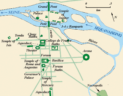 record. On the south side of the Seine, which Parisians call the Rive Gauche (Left Bank), a hill rises from the waterside. The surviving structures of the Roman town that grew on that hillside come in all shapes and sizes, but almost all of them are completely submerged in the modern city. Roman settlements sometimes incorporated elements of earlier villages, but more often the Romans laid out their towns according to a standard plan. The core feature of every colony was an intersection of two major roads called the cardo and the decuman. All other streets in the town, with rare exceptions , paralleled one of these two major roads. Roman towns expanded from this central intersection in orderly rectangular blocks.
At or near the intersection was the town's forum and capitolium. The forum was the center of commerce and administration , while the capitolium was a temple consecrated to the three primary deities of the Roman state: Jupiter, Juno, and Minerva. Above ground, Lutetia's forum was fairly simple, but it had complex underpinnings . To create a level space on its hilly site, engineers constructed vaulted underground galleries. A level platform a little smaller than a football field was laid out above them. The platform was closed in on all four sides by single-story porticoes. These shed like structures with their exterior colonnades were a provincial reflection of the arcaded and vaulted porticoes that flanked public buildings in Rome. Spaces between columns were used for shops or municipal offices.
A Reconstruction of the Roman Forum in Lutetia |
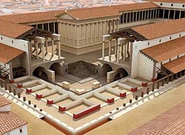
The open area of the forum served commercial or administrative needs as well as hosting shows and exhibits of various sorts. The temple of the state gods that stood near one end of the open area was small and undistinguished. Images of the gods inside the temple looked out over the forum and over a public altar where sacrifices were performed in their honor.
Houses and shops lined the streets around the forum, and a few of them followed the road downhill to a cluster of buildings on the island and a second small settlement on the right bank. In time, two administrative offices moved downhill as well. One of these was a basilica and the other was a palace . A basilica was a multipurpose structure often used by the Romans for law courts or administrative offices. At one end of the typical basilica the wall bulged out to form an apse , where figures of authority sat on elevated thrones while they addressed an audience or passed judgment. Porticoes around the perimeter of the building provided shelter in bad weather. Areas marked off by columns in the porticoes and in the interior could be closed with curtains or set off in other ways to create small offices, hearing rooms, or specialized courts.
The building that has been identified as a basilica in Paris occupied an entire city block. Incomplete traces of its outer walls and interior colonnade have been found to the west of the Rue de la Cite near what what was then the water's edge on the north side of the island. Putting this building along the river rather than in the forum suggests that the officers it housed were responsible for commerce and the regulation of the port.
Excavations under the cathedral of Notre Dame and the open square in front of it have uncovered a few Roman structures, and this archaeological site (open to the 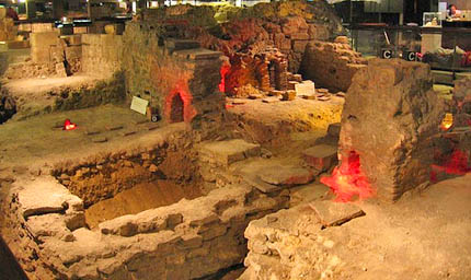 public) offers a narrow window into the life and fate of the Roman town . A trench dug in 1845 gave the first hints of what lay beneath. Systematic excavations began at the west end of the cathedral in 1847 when a confusing overlay of buildings from various periods was uncovered . Further campaigns in the late twentieth century have expanded well beyond the limits of these earlier digs and have uncovered structures that sketch the history of this core area of the city from the Roman era to the medieval period and beyond.
The most striking characteristic of the site is one that is easily lost on the modern visitor. The Seine, which now flows at a distance inside its walled channels, was, at the time the structures uncovered here were built, flowing right alongside them. Quite by accident , the 1847 excavators uncovered a small portion of the original shore of the island. The excavators also exposed the Roman engineering that transformed the Ile de la Cite from a mid-river mudflat of uncertain form into a permanent and well-consolidated mass. Sometime in the first century AD, workers began stiffening the edges of the island with wood pilings. In trenches above these pilings they dumped masses of soil, rock, and rubble to create a solid foundation. Atop and beside this rubble core, walls were built to hold the river back. Stair steps here and there in the river walls gave access to boats anchored along the quays. A roadway immediately behind the walls was left open so that ships could be loaded and unloaded.